Google Imagery

GIS Data Services
Demographic Data
We offer comprehensive population and demographic reports, market research and profiles, business locators and summaries, mapping of major shopping centers, tapestry segmentation, traffic counts, and site maps with custom details.
GIS Data /Custom Data Analysis
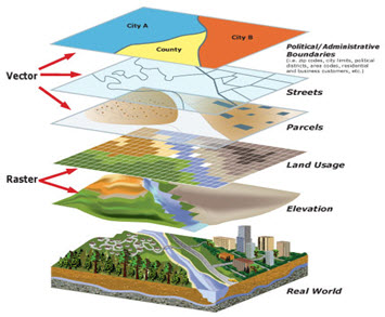
We offer essential GIS layers in the formats you need: Shapefiles, File Geodatabase, XML Workspace, and KML. We can provide specialized reports, data filters, advanced queries, data collections, automation, and maintenance and we employ skilled GIS Technicians who assist with GIS data automation needs.
GIS Data Hosting
We will store GIS Data on an Enterprise Infrastructure that is secured and regularly backed up, using the Oracle Spatial Database engine and ArcGIS server.
Geocoding
From sets of data as addresses, zip codes, latitude/longitude and cross streets, we offer custom reports, maps, and analysis designed to meet your boundaries, and much more. We support conversion from MS Excel, CVS, Text Files and more.
Google Earth EC Imagery and Information
We offer access to our Google Earth Enterprise Client (EC) that combines satellite imagery, County annually acquired imagery, maps and the power of Google Search to put the world’s geographic information at your fingertips. Fly from space to your neighborhood. Type in an address, parcel number or Point of Interest (POI) and zoom right in. Search for schools, parks. Get driving directions from one point to another. Tilt and rotate the view to see 3D terrain and buildings. Save and share your searches and favorites. Even add your own annotations. Google Earth EC lets you do smooth sailing flybys of the entire County and beyond. You can easily fly to any spot in the County and surrounding Counties, by entering any associated data, like street addresses, place names or latitude / longitude coordinates. There are County provided overlays that put additional information on the map, like roads, international boundaries, terrain, 3D buildings, crime statistics, schools, stadiums, any number of interesting stuff. You can design and develop your own tour of locations found in the County which you can convert to KML or Movies to share with other Google Earth EC users.

Data Layers
Google Functions
